-
Kubo: Puzzle coding concept

Meet the creative and playful KUBO. An educational hands-on and digital coding solution that provides everything needed to master coding and computational thinking, designed especially for kids.
Students learn to code using KUBO's unique TagTile® …
Translated by
 Tangible materialNew
-
Travle: Geographical knowledge

Travle is an interactive game where you get two countries on a map or two provinces. Your job is to get from one to the other. You do this by typing the name of a country or province and adding it to the map, on which your route becomes visible. …
Translated by
Interactive exerciseTeacher, ICT co-ordinator -
Seterra Geography: Blind map exercises

With the exercises on this website you can practice continents, countries, rivers, capitals, rivers on a blind map.
After selecting a card, you must click on what is requested by time.
Translated by
Interactive exercise (3)Teacher -
weADAPT: Climate adaptation

weADAPT is a global cooperation platform on climate change. Discover the latest knowledge, share your own work and connect with others dealing with similar challenges.
Translated by
WebsiteTeacher -
Go goals: SDG board game

The game is intended to inform children and young people around the world about the sustainable development goals in a simple and child-friendly way.
Translated by
Downloadable resourceTeacher -
European Space Centre

Euro Space Center is a Walloon activity center that introduces you to the daily life of astronauts. Relive the conquest of space and walk on the moon and Mars.
Translated by
WebsiteTeacher -
Brainstorm WIPASOFT: Practice site

Practice site with exercises supported by visual learning for various general subjects.
Translated by
WebsiteOther function -
Street Smart Learn

StreetSmart Learn is an online learning platform for all professionals who work with children and young people.
By following the hands-on, pragmatic and interactive programs on the platform, youth workers, teachers, ... can strengthen their knowledge …
Translated by
Website
-
European Union: Map
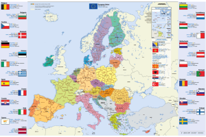
Map of the European Union, Dutch (or in another European language), in A4 format.
You will find this information per country: flag, capital, area, population, currency.
You can download or order this map.
Translated by
Downloadable resource
-
Le Livre Scolaire: Online Manuals

Le Livre Scolaire is a French publisher that makes its books available for consultation free of charge. Very useful for all subjects, including illustrations, but especially for language teachers.
You can usually download their own audios for free, …
Translated by
WebsiteTeacher -
Greentripper: Impact of travel on the environment

Traveling has an impact on our environment, on the climate... If you take the plane, you can calculate and neutralize the CO₂ impact of your trip by financing a CO₂ reduction project.
Translated by
Website (3)Teacher -
IRCEL: Interregional Cell for Environmental Measurements

This website provides your students with accurate air quality data in Belgium. For example, they can look up measurements of nitrogen, sulfur and carbon oxides, ozone, particulate matter and some organic compounds per municipality.
Translated by
WebsiteTeacher
Yummmm… cookies!
We don't like being tracked either. That's why we're concerned about your privacy.
Necessary cookies: for the proper operation of the website.
Functional cookies: for your convenience. recommended
Social media cookies: to view embedded media such as videos from YouTube, Facebook … recommended
Statistical cookies: for anonymous data collection to enhance user experience.